'State of the Lake' pour la baie Missisquoi
Le rapport aborde entre autres les sujets suivants : les faux hareng (p. 17), la biodiversité (p. 15), les cormorans (p.16), la pêche (p. 6), le phosphore (p. 8), les lamproies (p. 18), la baignade (p. 3), les nouvelles espèces invasives (p. 21), la protection des marais et des cours d'eau (p. 14), les moules zébrées (p. 19)
Certaines réponses s'appliquent spécifiquement à la baie Missisquoi. Elles concernent la baignade, la présence d'algues bleues, la comestibilité des poissons, le phosphore, la protection des marais et la biodiversité.
Puis-je me baigner dans le lac Champlain?
- Oui, la qualité de l'eau est généralement bonne pour la baignade. Plusieurs plages publiques font l'objet d'un contrôle : règle générale, la présence de pathogènes comme les bactéries coliformes n'y est pas suffisamment élevée pour justifier leur fermeture. Lorsque l'accès aux plages est interdit, c'est souvent à la suite de fortes pluies qui ont transporté vers les rivières et dans le lac des matières polluantes présentes sur le sol à travers l'eau de ruissellement. Les baigneurs qui s'aventurent sur des plages où la qualité de l'eau n'est pas vérifiée régulièrement devraient éviter de s'y rendre après les pluies abondantes surtout si c'est à proximité de l'embouchure d'une rivière ou d'une décharge d'eau de ruissellement.
>>> cote des plages de la Montérégie
Est-ce que la présence d'algues bleues constitue un danger?
Oui. Et c'est particulièrement sérieux dans la baie Missisquoi, la St. Albans Bay et quelques autres plus petites baies du nord-est. Dans la plus grande partie du lac Champlain, il n'y a pas prolifération d'algues bleues ni des niveaux critiques d'algues toxiques. Lorsqu'elles sont en trop grand nombre, elles forment une masse appelée fleur d'eau qui peut libérer des toxines cyanobactériennes susceptibles d'irriter la peau. Ingérées, ces toxines peuvent provoquer des problèmes gastrointestinaux et endommager le foie; le système nerveux peut aussi être affecté. Il faut donc éviter tout contact avec l'eau lorsqu'il y a présence de fleurs d'eau de cyanobactéries (photos), et veiller à ce que les enfants et les animaux de compagnie en restent éloignés.

Il y a toujours eu des algues bleues ou cyanobactéries, dans le lac Champlain; elle font tout normalement partie de son histoire biologique
Blue-green algae, or cyanobacteria, have been in Lake Champlain historically and are a normal part of its biology. Dense blooms, however, have increased worldwide in recent years?the Lake is no exception. Nuisance blooms were recognized as a
problem in the mid-1990s, when large blooms developed in Missisquoi Bay. Bloom locations vary annually and seasonally and the blooms are blown around by winds.
In Missisquoi Bay, microcystin concentrations regularly exceeded recreational use guidelines from July to September in recent years.
Can I eat the fish from Lake Champlain?
Le poisson du lac Champlain est-il bon à manger?
Yes, but health advisories for the toxic chemicals PCBs and mercury in certain fish should be considered carefully, especially by women and children. Recent studies show a significant reduction in PCB levels in Cumberland Bay?s sediments, as a result of a $35 million cleanup. These findings may allow the PCB-related fish advisories in the Bay to be lifted in the coming years. Mercury and PCBs, however, remain Lake-wide issues.
***No meal of any species recomended in Missisquoi Bay during July to January because of blue-green algae (cyanobacteria).
Are phosphorus levels too high in the Lake?
La concentration de phosphore est-elle trop élevée dans le lac?
Yes, phosphorus levels are too high in most parts of the Lake because of human activities. Missisquoi Bay, the Northeast Arm and parts of the South Lake greatly exceed the phosphorus standards or targets. But the Main Lake and Shelburne, Cumberland, Burlington, and Malletts Bays are near the targets. Large reductions have been gained from sewage treatment improvements, but great challenges remain to reduce phosphorus in nonpoint source runoff.

The Missisquoi sub-basin carried the highest phosphorus load (167.3 metric tons/year
in 1991) of the total 631.3 mt/yr load for the entire Basin. One metric ton (mt) is
about 2,205 pounds. Accordingly, this sub-basin must reduce the most phosphorus?70.1
mt/yr, to achieve the TMDL. In 2002, Vermont and Québec signed an agreement to allocate responsibility for reducing phosphorus in the Missisquoi subbasin
(Vermont 60% and Québec 40%).

Is it important to protect and restore wetlands and rivers?
Est-il important de protéger et de restaurer les marais et les cours d'eau?
Yes. Wetlands provide important habitat to fish, wildlife and plants. They also slow down the flow of runoff, filter sediments and naturally absorb phosphorus and pollution. Stable river banks and buffers are important in reducing the amount of sediment and pollution to the Lake.
Québec has protected more than 1,693 acres (685 ha) of wetlands near Missisquoi Bay with the aid of The Nature Conservancy and other local organizations?at a cost of
about $1.2 million (CAD $).
Are fish populations changing?
Y a-t-il des changements dans les populations de poissons?
Yes, fish populations have changed dramatically in Lake Champlain. Lake trout and salmon populations collapsed prior to the 1900s, but stocking and restoration programs have been established to restore these fisheries. Significant future changes are expected to result from nonnative species such as alewife and white perch.
Many biologists consider white perch a significant threat to biodiversity
in Lake Champlain. In 2003, Québec researchers found that white perch far
outnumber native yellow perch in Missisquoi Bay, and are now the Bay?s most abundant fish. The white perch may have displaced yellow perch by feeding on their larvae. Also, white perch may compete with yellow perch for zooplankton. In turn, fewer zooplankton are around to eat algae, which may increase algal growth.
Infos sur la moule zébrée
LAKE CHAMPLAIN FACTS:
Length: 120 miles (193 km)
Greatest width: 12 miles (19 km)
Greatest Depth: 400 ft. (122 m)
Average Depth: 64 ft. (19.5 m)
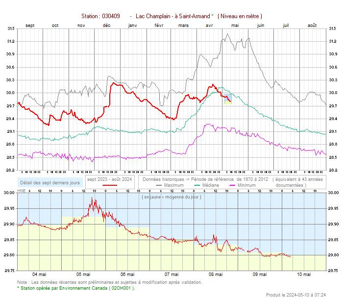
Average Annual Water Level: 95.5 ft. (29 m)
Water Surface Area: 435 sq. miles (1127 sq. km)
Area of the Basin: 8,234 sq. miles (21,326 sq. kms)
Population of Basin: 571,000
Basin Land Distribution: 56% Vermont, 37% New
York, and 7% Quebec.
Le rapport de 28 pages (en anglais) peut-être téléchargé ici.




0 commentaire(s) :
Cliquez ici pour inscrire votre commentaire.
Pour vous identifier, pointez « Autres » et inscrivez votre nom.
<< Retour à la page d'accueil